Saudi Arabia’s bizarre new megacity, “The Line,” is going full steam ahead. While construction began on the project in October, new satellite images have revealed how much ground the project has covered, the scale of the city’s length, and the layout of its construction site.
MIT’s Technology Review reviewed satellite images of The Line’s construction site from an Australian company called Soar, with a photo of the main base camp having been taken by a satellite from Chang Guang Satellite Technology Corporation on October 22, 2022. This main base camp is located at 28.10 degrees latitude and 35.30 degrees longitude on the western side of the Saudi Arabian peninsula, but Soar user Urban uploaded several images of construction occurring all along the length of the Line.

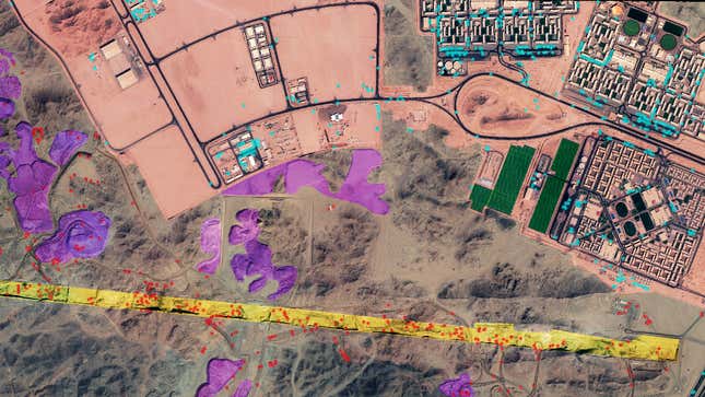
The color-coded version of the base camp shows the footprint of The Line being dug into the sand of the dessert, about 200 feet (60 meters) wide, according to Soar’s scale bar. Red dots indicate at least 425 excavation vehicles at work carving out the future city’s footprint, with an estimated 1.7 million cubic meters of rock and sand being dug up at this site alone. Urban’s image also characterizes different parts of the construction site, such as a main construction camp in pink that is being used to house workers and arrays of solar panels in green.
Another image shows construction in the city’s western site, which is located at approximately 28.15 degrees latitude and 34.68 degrees longitude. The image was taken on September 10, 2022 using a satellite from Singapore’s Twenty First Century Aerospace Technology Company, and shows 103 excavation vehicles with an estimated 0.7 million cubic meters of earth having been excavated from this particular portion of The Line. Urban also uploaded a status update with an image taken on November 18 that compares the area that has been excavated thus to the planned area.
The Line officially broke ground this past October, though Urban’s images clearly indicate that construction started at least a month earlier. The megalopolis will feature a mirrored exterior that contains a completely self-contained city that is 546 yards (500 meters) tall, 218 yards (200 meters) wide, and a whopping 105 miles (170 kilometers) long. With construction underway, the Saudi Arabian Crown Prince Mohammed bin Salman hinted at a potential completion date around 2030 in a Neom press release.