After a Chinese surveillance balloon flying over the US earlier this year provoked an international incident, open-source intelligence analysts went blimp hunting. Some zeroed in on an enormous hangar in a remote part of Xinjiang, which looked like the infrastructure needed to deploy some kind of lighter-than-air vehicle.
This collection of buildings and roads has been carefully watched for more than a decade. The complex, operated by the People’s Liberation Army (PLA), is thought by intelligence analysts to house research and development centers for laser weapons capable of attacking US satellites, as well as test facilities for ballistic missiles, electromagnetic pulse research—and balloons.
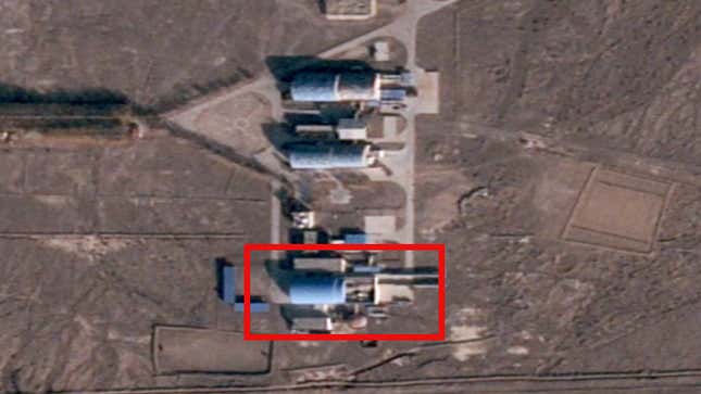
Now, using data from the satellite data company BlackSky, researchers have confirmed that China is fielding lighter-than-air vehicles at the facility.
“We’ve been able to image for the first time a 32-meter aerostat at that complex,” Sean O’Connor, the lead satellite imagery analyst at Janes, the defense intelligence firm, told Quartz, using a term of art for a lighter-than-air vehicle. “For the first time we can say, yes, this is balloon-related.”
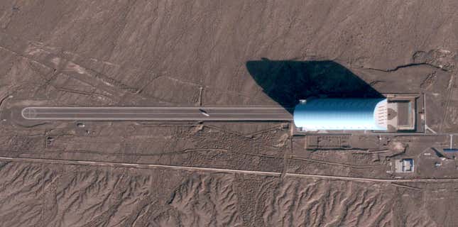
While the vehicle may look small from space, it’s about 100 feet (32 meters) long. The enormous hangar next to it—reminiscent of the old US blimp hangars in Silicon Valley that Google took over—is more than 850 feet (260 meters) long and 500 feet (140 meters) wide.
This likely isn’t the same kind of vehicle that was spotted and eventually shot down over the US. The AI firm Synthetaic was able to use data collected by space data company Planet’s satellites to retrospectively track that balloon back to a launch site on the Chinese island of Hainan.
So what is the PLA up to with this airship? Answering that question requires digging into the Xinjiang facility’s other features.
China’s pursuit of anti-space laser weapons
O’Connor, then using skills developed in the US Air Force as an amateur open-source intelligence analyst, was the first person to publicly identify this complex, often referred to as the Korla site, after a nearby city, or Bohu, after a nearby lake. In 2009, he spotted pictures of the site on Google Earth after seeing media reports about a Chinese laser development facility. Several buildings there had retractable roofs often seen at other sites developing directed-energy technology.
O’Connor and two former government intelligence analysts who didn’t want to be publicly identified believe that China is developing anti-satellite lasers there. Those ideas have been reinforced by open-source intelligence analysts, notably Jeffrey Lewis and Eli Hayes at the Middlebury Institute for International Affairs, who published a two-part series on the site late last year.
The researchers believe that the team at this facility is developing a vehicle-mounted laser that could briefly dazzle or permanently blind sensors used by satellites flying overhead; Russia possesses a similar system. Any remote-sensing satellite that gathers imagery of the Earth could be degraded by such a weapon, but the US military is most concerned about satellites that could give early warnings of missile launches against the US or its allies.
That is backed up by declassified US intelligence. Last year, the Pentagon released an assessment (pdf) of China’s military that noted “multiple ground-based laser weapons of varying power levels to disrupt, degrade or damage satellites that include a current limited capability to employ laser systems against satellite sensors.”
Still, a range of activitiescould be going on at the secretive facility. Analysts think it’s likely the lasers inside the buildings could be used to precisely measure the location of satellites overhead, improving China’s orbital awareness.
Lewis and Hayes used Planet data stretching back to 2015 and found that activity at the site, as measured by the opening and closing of those roofs, has intensified since 2020. Planet’s data is based mainly on a satellite design that images the site (and the world’s entire landmass) twice a day.
BlackSky’s constellation covers a more limited swathe of the planet, but it’s designed to revisit the same place seven or eight times a day. Analysts using its data have attempted to assess what time of day the roofs are most likely to be open in order to correlate which satellites might be overhead at the time, but haven’t reached a firm conclusion.
O’Connor cautions that despite the theoretical possibility of reverse-engineering the complex’s targets, the process is labor-intensive and may be complicated by the lack of imagery detailed enough to see which way the beam is pointed.
How to spot an airship from orbit
The challenge for intelligence agencies and independent analysts trying to understand China’s military from space is the limited set of clues. One open question is whether all the different kinds of research at this facility are connected or simply in the same area.
In the US, for example, the White Sands Missile Range and the nearby White Sands Test Facility in New Mexico are home to military programs working on missiles and lasers and civil space research. From space, it could be difficult to tell which programs are military and which of those are interconnected. Similarly, the analysts Quartz spoke to disagreed on the amount of connection between the programs at Korla.
O’Connor suggested there’s at least one good reason to think the aerostats and the lasers are linked: That small airship might be flown to a specific altitude and then targeted with the laser to help researchers understand how the beam passes through atmosphere.
But there are many open questions about the facility. Is there a large dirgible waiting inside that large hangar? A new runway has been developed to the south of the site—is it for landing drones, or testing anti-drone laser systems? What about a tall tower near equipment associated with electromagnetic pulse research—is it for calibrating radar signals, or something else?
The multibillion-dollar hunt for China’s next weapon
Still, since O’Connor first spotted the Korla site on Google Earth, a flood of privately obtained satellite imagery has made the job significantly easier. New companies like BlackSky and Planet are providing more and cleaner data to people who don’t have access to the US government’s highly classified satellite observations.
“More is always better than less,” O’Connor said, noting that today, he can take advantage of “a bunch of different providers and satellites, not all following each other, capturing different places around the globe, offering different capabilities.”
Billions of dollars have been invested in companies that are using novel sensors and satellite architectures to gather that data, while the US government has launched programs to develop and hire their capabilities. “The [space] industry is also benefiting—and will continue to benefit—from a rise in geopolitical tensions (China, Russia), which is driving more US government spending,” said Chad Anderson, a venture capitalist focused on the sector.
BlackSky, whose pictures confirmed the airship at the Korla site, uses machine learning tools to make its growing data library more useful to customers. Patrick O’Neil, the company’s chief innovation officer, said users of its Spectra platform can highlight an “overlay of specific locations at this site [that] detect whether there are anomalies in particular parts of a facility”—like if an airship was briefly rolled out of a hangar.